Civil 3D Grading: Modern Methods Every Engineer Should Know
More Than Just Levels
In modern site development, grading is no longer just about adjusting elevations or drawing contours. With the power of Autodesk Civil 3D, grading has evolved into an intelligent design process that directly impacts drainage performance, construction feasibility, earthwork balance, and overall project cost.
Whether you are designing residential developments, commercial sites, or large infrastructure projects, mastering grading ensures that your design is not only buildable but also efficient and compliant with engineering standards.
This guide explores the latest grading methods in Civil 3D, trending workflows used by industry professionals, and how tools like corridors and feature lines are transforming the way engineers approach site grading.
Why Grading is Critical in Site Design
Grading forms the foundation of every successful construction project. Poor grading can lead to drainage failures, structural risks, increased maintenance costs, and even permit rejection.
Effective grading ensures:
✅ Water flows safely away from structures
✅ Slopes remain stable and constructible
✅ Earthwork is optimized to reduce hauling costs
✅ Sites integrate smoothly with existing terrain
✅ Regulatory drainage requirements are met
Simply put — great projects start with great grading.
Latest Civil 3D Grading Methods Used by Professionals
The grading workflow in Civil 3D has significantly improved over the years. Today’s engineers combine multiple tools to achieve higher accuracy and faster design iterations.
Let’s explore the most effective and trending methods.
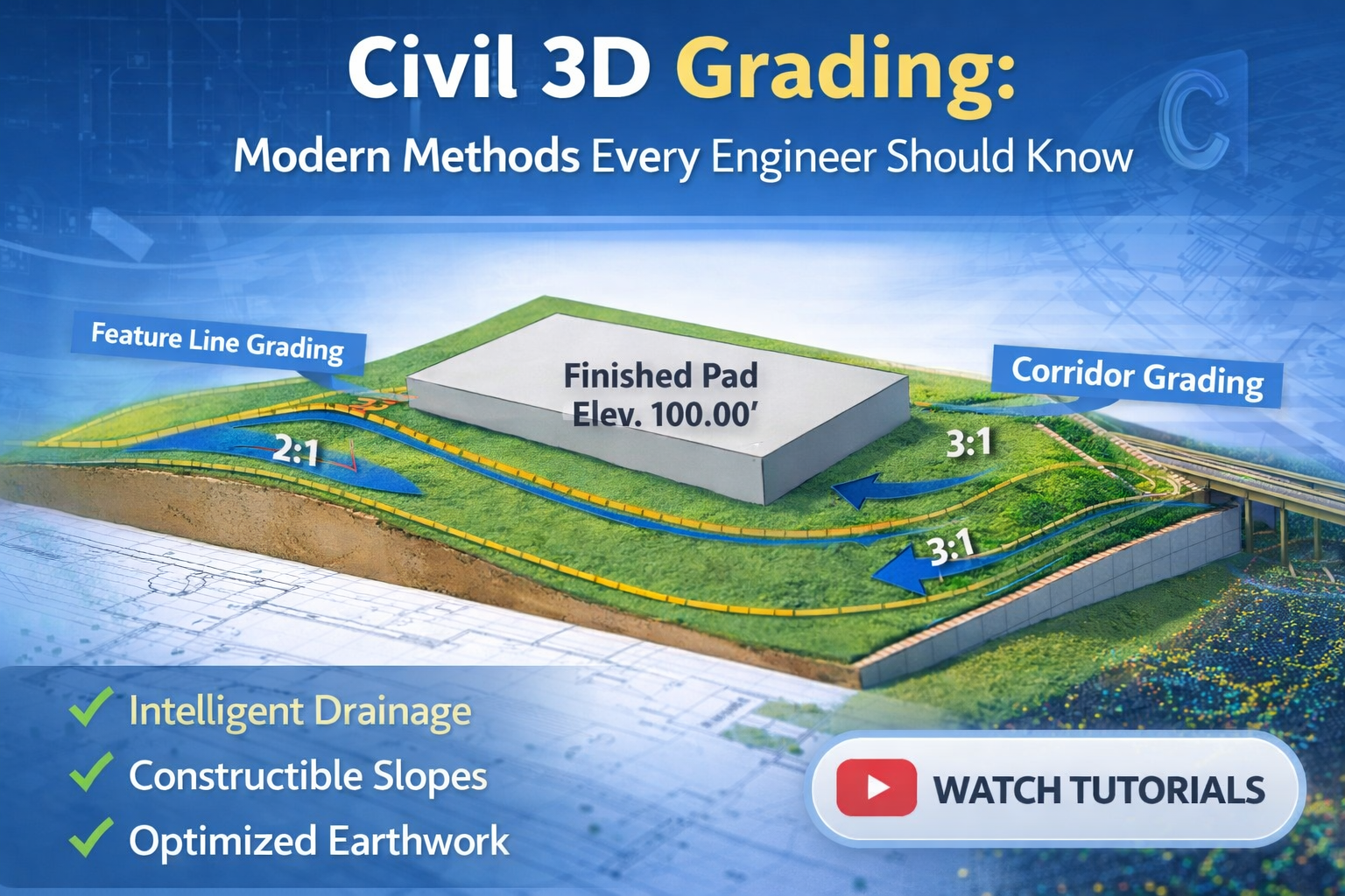
1. Feature Line–Based Grading (Industry Favorite ⭐)
Feature lines have become one of the most preferred grading tools because of their flexibility and precision.
Why Engineers Prefer Feature Lines:
- Dynamic elevation control
- Easy slope editing
- Smooth surface transitions
- Quick revisions without rebuilding the entire model
Feature lines act as 3D breaklines, allowing designers to control how the surface behaves between critical points such as pad edges, parking lots, sidewalks, and drainage channels.
Trending Technique:
Stepped Pad Grading
Instead of forcing large flat areas, engineers now design stepped building pads that:
✔ Reduce retaining wall height
✔ Minimize cut & fill
✔ Improve drainage
This approach is widely used in hillside developments.
Pro Tip:
Always assign feature lines to a grading surface immediately to visualize drainage behavior in real time.
2. Corridor-Based Grading (The Smart Automation Approach)
While corridors are traditionally associated with roadway design, they are now heavily used in complex site grading projects.
A corridor creates a parametric 3D model that updates automatically when alignments, profiles, or assemblies change.
Best Uses for Corridor Grading:
- Large residential subdivisions
- Industrial developments
- Parking lots
- Channel grading
- Access roads
Why Corridors Are Trending:
✔ Automation reduces manual grading
✔ Faster design updates
✔ Highly accurate quantity calculations
✔ Better tie-ins to existing ground
For projects with repetitive geometry, corridors can save dozens of design hours.
Advanced Workflow:
Many expert designers now combine corridors with feature lines — using corridors for primary geometry and feature lines for fine grading control.
This hybrid method is quickly becoming an industry best practice.
3. Grading Objects (Still Powerful When Used Correctly)
Civil 3D grading tools remain extremely effective for localized grading tasks.
Ideal For:
- Building pads
- Detention ponds
- Berms
- Swales
Grading objects allow you to apply criteria such as:
- Grade to surface
- Grade to elevation
- Grade to distance
Although some engineers avoid them due to rebuild limitations, they are incredibly efficient when applied strategically.
Smart Strategy:
Use grading objects for contained areas — not entire sites.
4. Surface-Based Grading (The Reality-Driven Method)
Modern grading increasingly starts with high-quality survey data, photogrammetry, and drone surfaces.
Designers analyze:
- Flow paths
- Low points
- Natural drainage patterns
Then shape the finished surface accordingly instead of forcing unrealistic terrain changes.
This approach leads to:
✅ Lower earthwork costs
✅ Faster approvals
✅ Environmentally responsible designs
Many municipalities now favor designs that respect existing topography.
Trending Civil 3D Grading Techniques in 2026
✔ Data-Driven Grading
Using drone surveys and point clouds for ultra-accurate surfaces.
✔ Earthwork Optimization
Balancing cut and fill directly inside Civil 3D to minimize trucking costs.
✔ BIM-Integrated Workflows
Grading models now connect with broader BIM environments for better coordination.
✔ Visualization Before Construction
Engineers generate realistic surface models to detect drainage issues early.
✔ Automated Quantity Takeoffs
Saving time during cost estimation.
Common Mistakes Engineers Should Avoid
Even experienced designers sometimes overlook grading fundamentals.
⚠️ Over-steep slopes that are difficult to construct
⚠️ Poor drainage planning
⚠️ Ignoring tie-ins to existing ground
⚠️ Excessive retaining walls
⚠️ Designing without considering equipment access
Remember — grading is both an engineering science and a construction strategy.
Expert Recommendation: Combine Methods for Best Results
There is no single “perfect” grading tool.
Top Civil 3D professionals typically use:
👉 Corridors for structure
👉 Feature lines for precision
👉 Grading tools for localized control
👉 Surfaces for validation
This layered workflow produces designs that are smarter, safer, and easier to build.
The Future of Civil 3D Grading
As projects become more complex, grading will continue shifting toward automation and data-driven modeling.
Engineers who master advanced grading today will:
✔ Design faster
✔ Reduce revisions
✔ Improve constructability
✔ Deliver higher-value projects
Grading is no longer just technical work — it is a competitive advantage.
Final Thoughts
Civil 3D grading is far more than adjusting levels — it is about shaping the land intelligently to support long-term performance and construction success.
By leveraging modern tools like corridors, feature lines, grading objects, and intelligent surfaces, engineers can transform challenging terrain into buildable, efficient developments.
👉 Master grading, and you master site design.
🎥 Learn Civil 3D Grading Step-by-Step
If you want to see these grading methods in action, we’ve created a dedicated Civil 3D Grading Playlist where students and professionals can learn through practical, real-world examples.
✅ Feature line grading tutorials
✅ Corridor-based site grading
✅ Drainage-focused workflows
✅ Earthwork optimization techniques
✅ Beginner to advanced lessons


A really good blog and me back again.