How to Create Surface in Civil 3D from Survey Data Guide by Civil 3D Pro
How to Create Surface in Civil 3D from Survey Data ? Making a surface in Civil 3D from survey data is an important part of civil engineering projects. The surface model is an important part of accurate topographic analysis, whether you’re building roads, highways, or any other kind of infrastructure. Civil 3D Pro is all about helping engineers and surveyors use Civil 3D’s sophisticated tools to get results that are accurate and dependable. In this article, we’ll show you how to quickly and easily make a surface from survey data.
Following these procedures will help you construct a strong surface model using survey data. Civil 3D Pro is there to help you with more advanced Civil 3D capabilities or if you have particular project demands. Don’t hesitate to get in touch with them.
Why You Need to Create a Surface in Civil 3D
A surface shows the ground level or landscape of a site. When you import survey data, you acquire basic measurements from the field, such as elevations, points, and features that you need to turn into a 3D model. Civil 3D uses this information to make a surface model, which is used for:
- Designing grading for roads, parking lots, and other projects.
- Performing cut-and-fill calculations for earthworks.
- Visualizing terrain to guide planning and decision-making.
- Creating contour lines for further design and analysis.
Now, let’s get into the steps you need to follow to create a surface from survey data in Civil 3D.
Step 1: Import Your Survey Data into Civil 3D
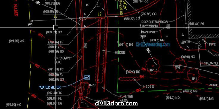
You need to upload your survey data into Civil 3D before you can start making a surface. Survey data usually comes in several formats, such as CSV, TXT, or even straight from the tools used to do the survey.
Here’s how to import it:
- Open Civil 3D: Start by opening your Civil 3D project or creating a new one.
- Go to the “Insert” Tab: In the main ribbon, click the “Insert” tab, and then choose “Import Survey Data.”
- Choose Your Data Format: Select the survey data format (such as CSV or TXT), browse for your file, and import it into the drawing.
When you import the data, the survey points will show up as point objects in your sketch. Check that the data is correctly georeferenced.
Step 2: Create a New Surface
Now that your survey points are in the project, the next step is to create the surface:
- Open the “Toolspace” Panel: If you don’t already have the Toolspace open, go to the “Home” tab and click “Toolspace.”
- Navigate to the “Surfaces” Tab: Under the Toolspace panel, select the “Surfaces” tab.
- Create a New Surface: Click on “Surfaces” and then “Create Surface.” Pick the sort of surface you want in the “Create Surface” dialog box. A TIN Surface (Triangulated Irregular Network) is what you’ll use for most projects. It’s great for showing uneven ground.
Here, you’ll be prompted to give the surface a name and define its style. It’s recommended to keep the name descriptive, such as “Site Surface” or “Road Design Surface,” to stay organized.
Step 3: Add Data to the Surface
Now that you have a surface created, you need to add the survey data to it. Civil 3D makes this easy through the “Add Data” feature. Here’s how:
- Right-Click the Surface: In the Toolspace panel under “Surfaces,” right-click your newly created surface and select “Add Data.”
- Select Point Data: In the “Add Data” dialog, select Point Groups (from the survey data you imported) or manually add the points by selecting Point Files.
- Add Breaklines (if needed): Breaklines are critical for defining edges or other features that need special treatment (like roads or rivers). You can add breaklines manually or by selecting existing entities in your drawing.
This is where you can also fine-tune which point data is included. Typically, you’ll want to include all points that represent the surface terrain but exclude outliers or erroneous measurements.
Step 4: Analyze and Refine the Surface
Once your surface is created, it’s time to analyze and refine it:
- Inspect the Triangulation: Civil 3D makes a triangulated surface by itself. But it’s important to look at the mesh. You might wish to look for any odd spikes or holes that need to be corrected.
- Smooth the Surface: You can use the Surface Tools to smooth the surface if you need to. You can also change the triangulation to make it more accurate and better mimic the terrain in the real world.
- Add Contours: For seeing variations in elevation in your model, contours are quite important. Civil 3D makes contours automatically depending on the surface, but you can change their style and interval to fit the needs of your project.
Step 5: Export and Share Your Surface Data
Once your surface is created, analyzed, and refined, you can export it or share it with other team members:
- Export the Surface: Civil 3D allows you to export your surface in various formats such as DWG, DXF, or LandXML for use in other CAD software or analysis tools.
- Generate Reports: Civil 3D also allows you to generate surface reports, such as volume calculations, slope analysis, and area computations.
- Share with Stakeholders: Export the surface data to stakeholders or integrate it into your overall project design for collaboration.
Best Practices for Working with Survey Data in Civil 3D
To ensure the best results when creating surfaces from survey data, here are some tips:
- Quality Check Your Survey Data: Before importing, ensure your survey data is accurate and complete. Check for missing points, erroneous data, or misaligned coordinates.
- Use Appropriate Surface Styles: Customize the surface style to suit your project’s needs. For example, you might want different contour intervals for a small site versus a large landscape.
- Consider Surface Smoothing: If the triangulation produces jagged or unrealistic results, use smoothing options in Civil 3D to get more accurate and usable surfaces.
Why Choose Civil 3D Pro?
We at Civil 3D Pro focus on offering Civil 3D services and training to people who work in civil engineering. Our staff is here to help you expedite your work and get the greatest results for your projects, whether you’re making surfaces, grading roads, or doing in-depth analysis.
We have years of experience and a deep grasp of Civil 3D, so we can assist you make sure that every step of your design process is precise and efficient. Contact Civil 3D Pro today for one-on-one help and professional training on how to get the most out of your survey data in Civil 3D.


Aw, this was a really nice post. In idea I want to put in writing like this additionally – taking time and actual effort to make an excellent article… however what can I say… I procrastinate alot and not at all seem to get something done.
Thanks
I am glad to be one of several visitants on this outstanding web site (:, appreciate it for posting.
Thanks